Trip Report: Tieton River - Sept 12, 2021, 1850 cfs
Tieton River Annual Flip-Flop Run
Submitted by Bruce Eicher
As many of you know each September while most of our favorite river runs have dried up, the dam keepers of Rimrock Lake open the gates. From what I understand this water water flow is increased for Yakima irrigation needs when they lower the flow of the upper Yakima to improve the salmon spawning conditions, hence the Flip-Flop destination. So boaters from all around come to take advantage of this healthy flow for a late summer paddle or row.
 As this was my first time on this river I asked around and found Craig with some local experience willing to meet me up there Sunday the 12th. Sarah Marie with her small cat and Terry Bailey paddling an Aire IK agreed to join me, also in a IK. Craig was up there camping for a long weekend and gave me his campsite coordinates to meet near the put-in.
First breakfast; Sarah, Terry, his wife Shari and I met at Sticky Fingers Bakery and Cafe in Naches. Good choice for great food and service with indoor and outdoor seating. Yakima Valley along with Naches had some smoke from the fire North North West, in fact we were now in a level one evacuation zone. At that time the fire was more active and moving North, away from Naches and the Tieton River.

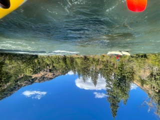
With full tummies and some leftovers the drive up Highway 12 gave us a look at the Tieton rushing parallel to the highway. I had studied Jeff and Tonya Bennett’s Washington River Guide, a great resource for most rivers in Washington and Northern Oregon. The Tieton is divided up in two runs, cleverly named Upper and Lower. We were doing the upper, rated a class III to III+ depending on flow range and opinion. Sunday’s flow was 1850 cfs. Flow range is 1000 to 3200. Gradient is listed at 61’ with a 10-11 mile distance we planned 3 hour float. Now since this river is in a somewhat higher than normal flow range the banks are covered with brush, so we expected very few good eddies and we noticed this on the drive up. Quite continuous white water, lots of waves, and a few rocks. And the river splits around numerous islands that all look alike. I wondered how we would know which channel to take.
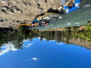
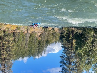
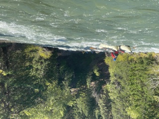
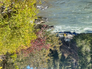
Our planned take-out, Windy Point Campground was actually closed, most likely due to the fire. But we found just up the highway the actual takeout was right downstream from a bridge, plenty of parking just 30 or so feet from the water. Locals we discovered call this Bridge Two because it is the second highway bridge in about an 1/8th of a mile, easy to expect and make the swift water, small Eddie take-out.
 Moving up to our chosen put-in, Tieton River Rimrock Campground we found our experienced leader Craig. But as it turned out Craig had rolled up and packed away his boat for the weekend. He and another gave us some river beta that sounded good to us, we found ourselves pumped and ready to hit the rolling water. But also edging on safety we gathered permission to join another group that happened to be many off duty local guides.
BTW; there is tons of primitive camping areas along the river, open first come type I believe. Even though it was a busy weekend it seemed like twice the people could easily fit. Also I see more camping up on the Rimrock Lake.
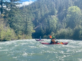
The run itself was just as advertised, fast with very few breaks in the white water, though mostly class 2 waves, not technical, just fun and splashy. The locals knew which channel to take around each of the many islands, though most could be taken either side in today’s flow range. There are many wood features but non we could not see and avoid, just had to stay alert. But like the published reports say, this is not a beginner run because of the water speed, lack of eddies, and likely strainers.
 The river was not a crowded as we might expect. Most likely the fire, smoke and small chance of evacuation kept many away. The river traffic did have a large percentage of small cats, a few round boats, IK’s, and least seemed hardshell kayaks.
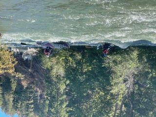
After an hour and about half way of our run we all stopped for a break on the left bank of an Island for some snacks and a chance to talk. Just around the corner was a low head diversion dam, one which is most often run rather than portaged. We were glad to have the experienced to help us navigate this drop of claimed 6-7’. The game plan was to take the right channel of the next island, the left channel was narrow and had some wood. But then cross back to the left bank right after the island and take the dam drop about 20’ off the left bank. They reported rebar could ruin your day near river center and river right had stronger recirculating current. And once we made the drop it was said to let your boat bounce into the left wall below, then back off in reverse. Sounded fun!? Terry though he might portage just to be safe. Well, once back into the fast moving water, following our guides, we all went right over the dam like good little ducks following our mother, little time to find the portage. The drop was more of a steep slide with a big standing wave on the bottom, I know Terry did speak a choice four letter word on the way down, but we all easily made this drop given the right position. And yes we played off the left bank wall a little bit as recommended rather than fight the lateral wave to miss the wall.
The river kept up the fast and fun pace, giving us many big waves, several holes to punch, some big rocks to dodge and a little wood to avoid. Two named rapids, both class III presented some excitement but no problems. House Rock offered a couple holes to avoid and big rocks for a chance at a game of pinball. Then a few bends later Waffle Wall, a couple more rocks, holes and strong current against a steel waffle retaining wall. I imagine at a higher flow these rapids could be more challenging. I believe the flow this year was not much higher than the 1850 we ran on this day.

Passing quickly under bridge one then two we found ourself at our Windy Point take-out after 2.5 river hours. And another clue of the take-out, it became windy, go figure.
We lucked out, the river flow was great, the sky was clear despite the fire, and we found some great guides to help us with the float. You just can’t beat the camaraderie on the river!
 So when all goes well, do it again! Eight days later September 20th, this time with hardshell kayaker friend Lynn. The flow was down to 1250. I had been watching it drop about 50 cfs each day. And on a Monday, the river was almost all ours. The flow was not as fast, but still fun, maybe a few more exposed rocks. One change was Lynn played it safe to portage the dam. Same route; river right of the last island before the dam, a strong ferry at the bottom of the island to a small Eddie just before the left turn to the dam. I hung back in the island Eddie till Lynn was out and hiking the easy trail then made the drop over. The lower water seemed to make the drop more vertical and less of a standing wave at the bottom. But it did not hold me, I easily punched through. The rest of the paddle was as before. Maybe next year we can find 2200 cfs or more. :)
Photos submitted by Bruce Eicher